Ask longtime Riverside Drive residents if it floods in their neighborhoods and you’re likely to hear tale after tale of how canoes or boats were used to get to their homes over the years. Some refer to mass flooding that occurs throughout the county. A few individuals even reference a time when they remember the Ogeechee and Savannah rivers meeting.
During the June public meeting concerning the treatment facility, several citizens questioned Guyton’s hired engineer, Carl Hofstadter of Hofstadter and Associates, about their plans to build in an area prone to flooding. They told city council and the engineers that the land was in a flood zone. And according to the appraisal for the property formerly known as the Griner B tract, the 384 acres are within a HUD identified special flood hazard area.
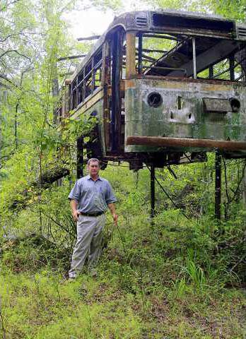
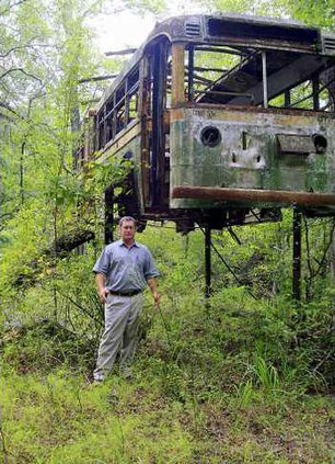
In photographer Jack Leigh’s book on the Ogeechee River, he shares the story of how in 1952 “Kenneth Wallace hoisted a 1940 Savannah Transit Authority bus unto stilts to use as a hunting and fishing lodge.” According to Leigh, Wallace “determined the height of the stilts by remembering the place on the trees where the water had risen in the great flood of 1929, the year the Ogeechee covered miles of land in all directions.”
In 1980 the river flooded again, this time Wallace said he and his wife “paddled their canoe to the old bus and found the water lapping right at its bottom.” They nailed a metal marker on one of the trees to depict the high water point.
That bus still stands on stilts right where Wallace erected it — on property Craig Barrow purchased in 1996, property located next door and across the street from where the city of Guyton proposes to build a 500,000 gallons-per-day wastewater treatment facility and install a land application spray field.
If Guyton and Hofstadter build a plant to treat wastewater to urban water reuse standards, then according to the Geosciences Engineering Detail Soil Investigation and Hydrologic Assessment Report on the proposed property sites (totaling 646 acres), very little of the soil is actually suitable for a land application system.
“After allowing for this (10-foot) buffer and excluding unsuitable/marginal soils, approximately 191 acres of year round suitable and 20.1 acres of seasonably suitable soils exist for this project,” the report contends.
Even Hofstadter and Associates reference the floodplains in the environmental information document submitted to the Environmental Protection Division:
“The proposed WWTP and LAS sites lie in close proximity to the Ogeechee River and as a result floodplain disturbance is a concern.”
However, the design development report does not outline any specific flood proofing, nor does it address plans to elevate the facility.
The Environmental Protection Division can, however, require that the plant meet certain requirements if it’s determined that the property is indeed within the 100-year floodplain.
Curtis Boswell of the EPD, in a previous interview, said the FEMA map of the property outlining flood zones looked “like ink was spilled on it” because of all the area deemed in Zone A — an insurance rate zone that designates areas considered to be in the 100-year floodplain. However, only a hydraulic analysis can determine the precise base flood elevation.
In Geosciences soil survey, they point out that there was a large portion of the Griner tract not investigated.
“The area mapped by the (Natural Resources Conservation Services) as Chastain, Tawcaw, Pelham and Pickney are too wet for land application of wastewater and were not investigated,” the report contends.
Guyton plans to build a five-to-10 acre facility on the 265-acre property furthest away from the river (across Riverside Drive) where there are 113.3 acres of suitable soil. They intend to place a 100-acre (plus or minus) spray field on the Griner tract where there is 97.8 acres of suitable soil out of a 384-acre parcel.
However, if long-time residents are correct and the road and area is prone to flooding, then even if there is suitable soil on uplands, access to and from the plant and spray field could prove daunting and costly if or when a flood occurs.
As it stands now, Guyton has to have water and sewer capacity or else future development could be nonexistent. They have three options: build their own plant, stay with Springfield but with increased capacity that EPD has to approve, or tie-in to Effingham County’s 1 million gallon-per-day facility.
If they stay with Springfield, they will have to wait until EPD approves Springfield’s expansion plans and the capacity is available.
If they tie in with the county, they will have to install piping to the county’s plant which would cost anywhere from $4 million to $8 million, according to Guyton Alderman Phillip King.
If they move forward with building a plant, then they will probably need to address flooding concerns, wetlands and potential of pollution from raw sewage that could be discharged into the Ogeechee River in the case of a major flood.
Assessing global climactic changes and storms over the past century could be one way for Guyton to determine if there is a likelihood of severe or major flooding along the Ogeechee River.
However, it could also be helpful to look to the past 15 years of unexpected, devastating storms that have wreaked havoc across the U.S. and see how other communities, counties and states have dealt with pollution and flooding issues of wastewater treatment facilities in flood-prone areas.
Learning from other’s experiences
As it stands now, Guyton City Council plans to construct a 500,000 gallons-per-day sewage treatment plant and install a land application system on Riverside Drive — a road and location that long-time residents say is known for flooding. Even the October 2007 land appraisal shows the property in a HUD identified special flood hazard area. Yet, they purchased the properties anyway.
Is it possible that actions and suggestions made by other states and state agencies since the Great Flood of 1993 could influence their decision to move forward?
The June historic floods in the Midwest caused massive flooding of sewage plants and the discharge of millions of gallons of untreated wastewater into local rivers and streams. Wisconsin’s Department of Natural Resources reported that at least 161 communities released raw sewage into nearby waterways.
In response, the Association of State Floodplain Managers went before the U.S. House Transportation and Infrastructure Subcommittee on Water Resources and Environment on June 24 with a report on comprehensive watershed management and planning.
“The recent flooding tragedies in the Midwest again demonstrated some major problems with how we manage our watersheds in this nations,” ASFPM executive director Larry A. Larson said in his testimony. “While many people seem to think the recent flooding was ‘unexpected’ or ‘unpredictable’ the history in our nation and the world provide ample evidence that large natural disasters occur frequently and with a vengeance.”
The recent flooding brought out “vivid examples of the failure of some of the nation’s watershed management approaches,” testified Larson.
He outlined various approaches and future trends before addressing the infrastructure and construction of wastewater treatment facilities.
“It is critical to have consistently applied standards for selecting safer locations or requiring mitigation measures for such critical facilities as … water and wastewater treatment facilities,” said Larson.
He went on to explain that facilities like sewage treatment plants “too often are located in floodprone areas, precipitating subsequent arguments that flood control structures are needed to protect them.” And even if the facilities were not considered a flood hazard initially, “now are or will be exposed, both because of the rising flood levels brought by urbanization and changes in climate and because of more accurate estimates of flood levels.”
While Larson’s testimony touched upon a number of floodplain issues and recommendations, it was not the first time an agency has responded to a natural disaster by asking government officials to consider more stringent, proactive measures to reduce flood hazards.